Airport Runway Information

Airport Diagram might not be current.
Location
| FAA Identifier: | EZS |
| Lat/Long: | 44-47-13.13.2200N / 088-33-32.2500W 44-47-13.13.2200N / 088-33-32.2500W44-47.220333N / 088-33.537500W44.7870056 / -88.5589583(estimated) |
| Elevation: | 813 ft / 247.8 m (surveyed) |
| Varitation: | 02W (1995) |
| From City: | From city: 1 mile NE of SHAWANO, WI |
| Time Zone: | UTC-5 (UTC-6 during Standard Time) |
Airport Communications
| CTAF/UNICOM: | 122.800 |
| GCO: | 121.725 |
| GREEN BAY APPROACH: | 119.400 |
| GREEN BAY DEPARTURE: | 119.400 |
| WX AWOS-3P at EZS: | 118.650 (715-526-2967) |
• APCH/DEP SERVICE PROVIDED BY MINNEAPOLIS ARTCC ONF FREQS
125.55/370.9 (GREEN BAY RCAG)WHEN GREEN BAY APCH CTL CLSD.
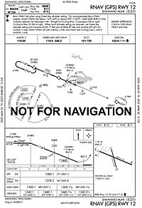
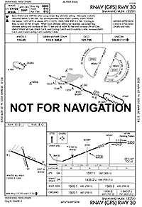
Runway 12/30
| Dimensions: | 3900 x 75ft. / 1189 x 23m |
| Surface: | asphalt in good condition |
| Weight bearing capacity: | Single Wheel: 17000 lbs |
| Runway edge lights: | medium intensity |
| WX AWOS-3P at EZS: | 118.650 (715-526-2967) |
| Runway 12: | Runway 30: | |
|---|---|---|
| Latitude: | 44-47.362667N | 44-47.116833N |
| Longitude: | 088-34.005000W | 088-33.172500W |
| Elevation: | 810.8 ft. | 810.6 ft. |
| Gradient: | 0.1 ft. | 0.1 ft. |
| Traffic pattern: | left | left |
| Runway heading: | 115 magnetic, 113 true | 295 magnetic, 293 true |
| Runway end identifier lights: | no | no |
| Touchdown point: | yes, no lights | yes, no lights |
| Obstructions: | 15 ft. road, 480 ft. from runway, right of centerline 18:1 slope to clear | 67 ft. trees, 1750 ft. from runway, 23:1 slope to clear |
 |  |
|
Runway 17/35
| Dimensions: | 2225 x 60ft. / 678 x 18m |
| Surface: | asphalt |
| Runway edge lights: | medium intensity |
| Runway 17: | Runway 35: | |
|---|---|---|
| Latitude: | 44-47.412667N | 44-47.059167N |
| Longitude: | 088-33.689333W | 088-33.554833W |
| Elevation: | 809.0 ft. | 813.2 ft. |
| Gradient: | 0.1 ft. | 0.1 ft. |
| Traffic pattern: | left | left |
| Runway heading: | 167 magnetic, 165 true | 347 magnetic, 345 true |
| Runway end identifier lights: | no | no |
| Touchdown point: | yes, no lights | yes, no lights |
| Obstructions: | 15 ft. road, 480 ft. from runway, right of centerline 18:1 slope to clear | 50 ft. trees, 1200 ft. from runway, 23:1 slope to clear |
Seaplane ALL/WAY
| Dimensions: | 12000 x 1000ft. / 3658 x 305m |
| Surface: | water (802 ft. elevation) |
| Runway ALL: | Runway WAY: | |
|---|---|---|
| Traffic pattern: | left | left |
Grass Areas
| Grass areas of the airport: landing at your own risk |
Our Partners
City of Shawano
www.cityofshawano.com
Shawano County
www.co.shawano.wi.us
Shawano Country Chamber
www.shawanocountry.com
Shawano County Economic Progress, Inc.
www.shawanoecondev.org